
Terra Australis 1606 – The voyages of Willem Janszoon and Luis Vas de Torres and the first European discovery of Australia
This talk was presented at the SMSA and will be broadcast by ABC Radio National on their ‘Big Ideas’ program. The maps and a brief text are presented here for the benefit of listeners to that program.
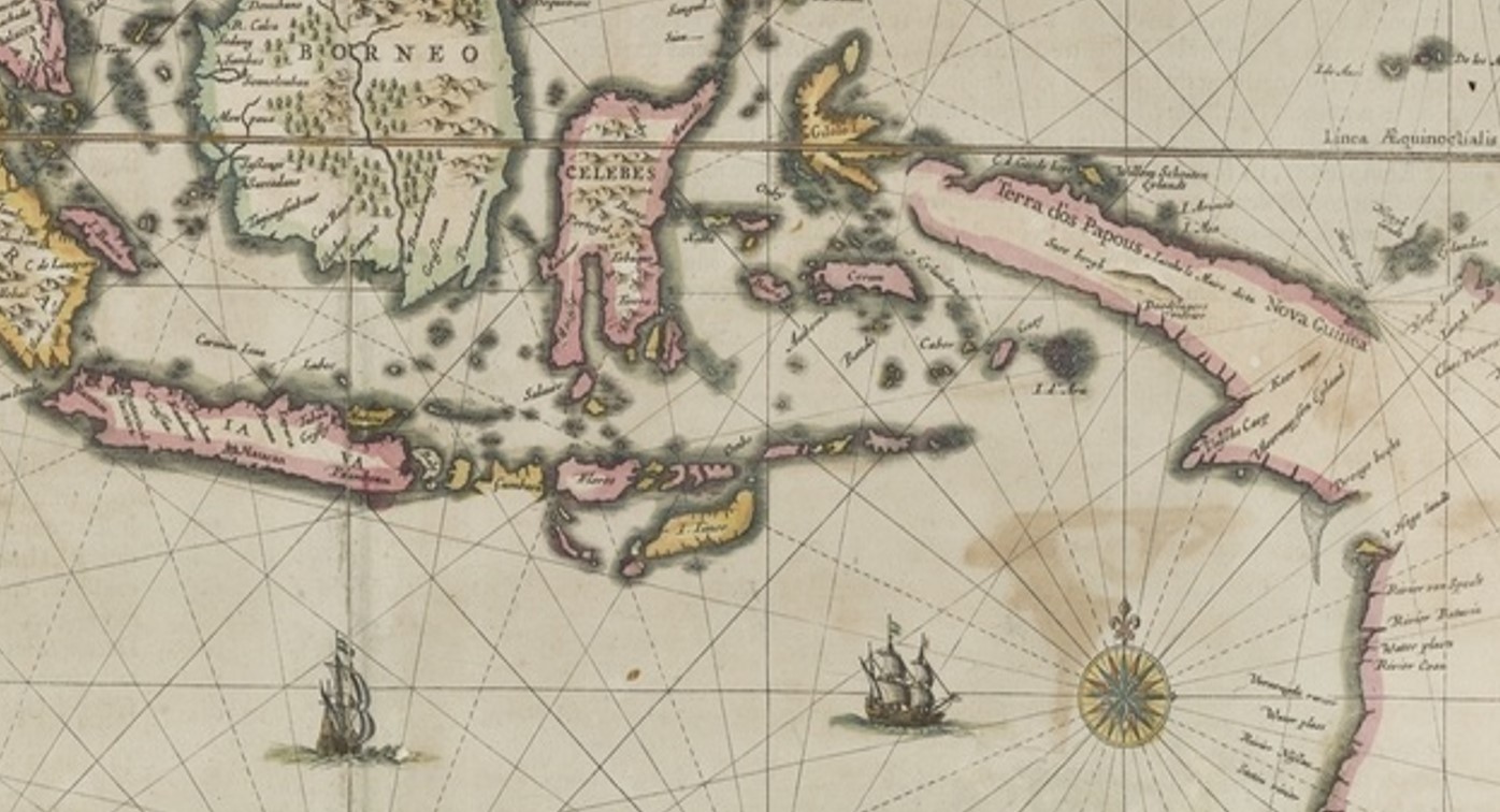
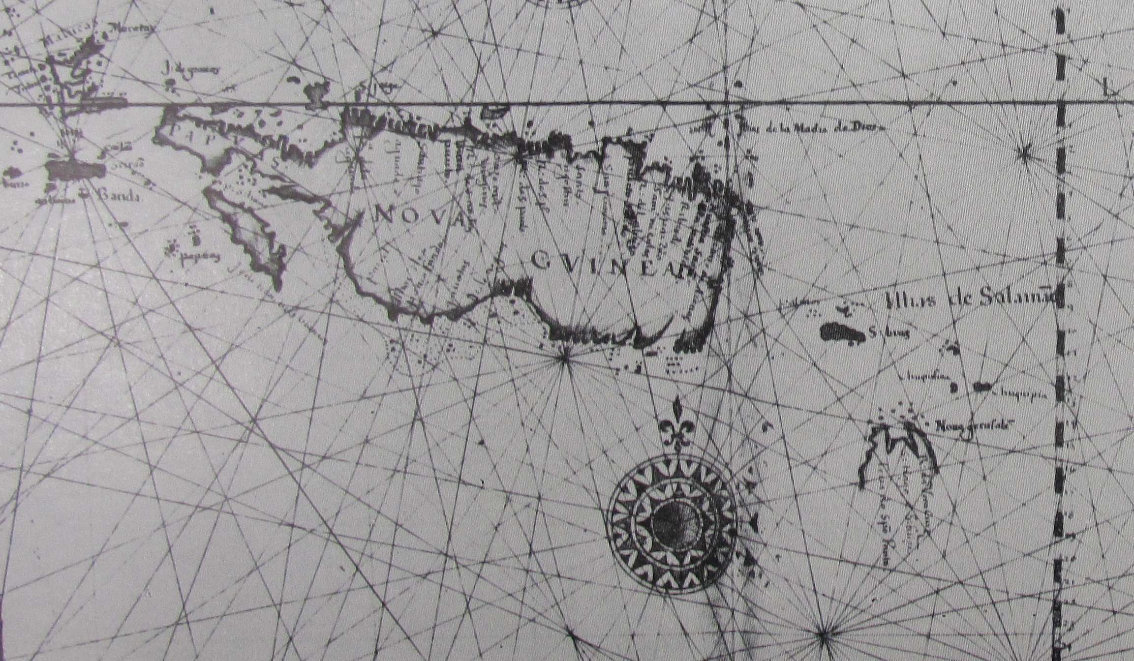
Hendrick Hondius 1641
In 1528, the Spaniard Alvaro de Saavedra commanding the Santiago attempted to sail from the Spice Islands of Eastern Indonesia back across the Pacific and charted the north coast of New Guinea which he named Isola Del Oro (Island of Gold). To be renamed Nueva Guinea by another Spaniard, Inigo Ortez de Retez in 1545.

Petrus Plancius 1594
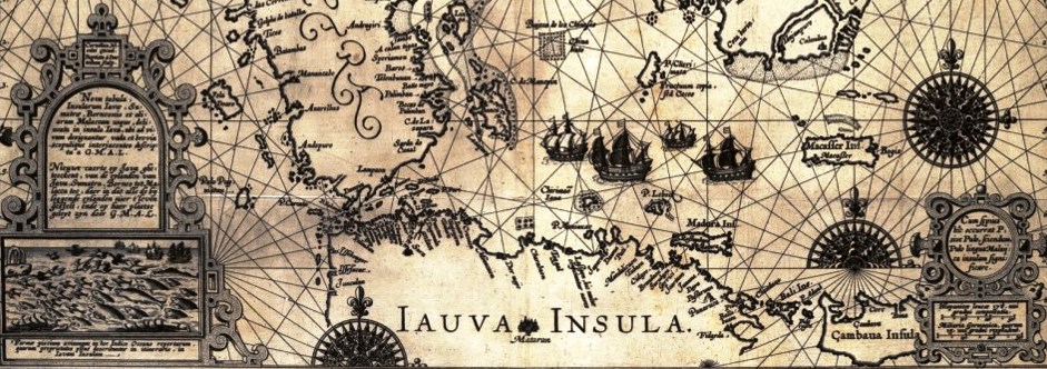
In 1595 the yacht Duyfken (Little Dove) sailed with the first Dutch expedition to the East Indies which was funded by ‘The Company for Far Distant Lands’ a precursor to the United Dutch East India Company (VOC). The fleet reached Banten near the Sunda Straits and began trading for spices, this map shows the fleet in the Java Sea and the Duyfken is the smaller of the vessels.
Willem Lodewijcksz 1595
Willem Janszoon in the Duyfken
After the first VOC war fleet captured the Portuguese forts in Ambon,Banda and Ternate in 1605 the Duyfken commanded by Willem Janszoon departed Banten and then Banda for a voyage of discovery along the south coast of New Guinea. Captain John Saris of the English East India Company in Banten reported:
The eighteenth (November 1605) here departed a small pinnasse of the Flemings, for the discovery of the island called Nova Ginnea, which, as it is said, affordeth great store of Gold.

The replica Duyfken in Banda
The ships log and maps of the 1606 Duyfken voyage have never been found in the VOC archives. But it was while examining the volumes of a Blaeu Atlas originally belonging to Prince Eugene of Savoy, first in 1920 and again in 1931 at the Hofbibliothek in Vienna, that Dr F.C.Wieder found it also contained the “Secret Atlas of the East-India Company “–copies of original maps no longer in the company’s archives–including the charts of the voyages of the Duyfken to New Guinea and Australia in 1606, and also of the Arnhem, which accompanied the Pera in 1623.

The voyage of the Duyfken 1606 from the ‘Secret Atlas of the VOC’
In March 1606 the Duyfken reached what is now Cape York and made the first European encounter with the Australian Aborigines, then returning via the south coast of New Guinea where some of the crew were killed in an encounter with the Papuans.
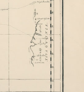
Detail of the west coast of Cape York from the ‘Secret Atlas of the VOC’
The Duyfken returned to Banda,then Banten, and Captain John Saris of the English East India Company again reported:
The fifteenth of June (1607) here arrived Nockhoda Tingall a Cling man from Banda in a Java Junke, laden with mace and nutmegs …
He told me that the Flemmings Pinnasse, which went upon the discovery for Nova Ginny, was returned to Banda, having found the island: but in sending their men on shoare to intreate of trade, there were nine of them killed by the heathens, which are man-eaters: so they were constrained to return, finding no good to be done there
Luis Vas de Torres in the San Pedrico
In 1606 Pedro Ferdinandes de Queirós led a Spanish expedition across the Pacific to discover the ‘Great South Land’. They reached Vanuatu and named it Tierra Australis de Espiritu Santo. On the night of 11 June 1606, Queirós in the San Pedro y San Pablo became separated from the two other ships of his fleet in bad weather and then sailed to Acapulco in Mexico. Luis Vaz de Torres with the galleon San Pedrico and the tender Los Tres Reyes sailed south east looking for the Great South Land, before turning north to sail to Manila. Unable make the north coast of New Guinea due to the prevailing winds, they turned east to follow the south coast of New Guinea.

William Dalrymple 1764
Showing the Torres voyage
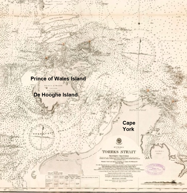
Again the ships logs and maps of the Torres voyage are missing but details have been reconstructed from a letter by Torres from Manila in 1607 and by a report by the second in command, Diego Prado y Tovar after he returned to Spain in 1615. The San Pedrico finally cleared the Torres Strait between the Dutch named De Hooghe Island (High Island) and Cape York and as descibed by Prado:
We were amongst reefs and shoals for 34 days’… there were many large islands and they appeared more on the southern side
After clearing the Torres Strait the Spanish ships sailed for the Spice Islands where Torres left 20 men and the tender Los Tres Reyes to reinforce the Spanish fort on Ternate before continuing to Manila.
A credible outline of New Guinea appears on a World Map by the Portuguese cartographer Godinho de Eredia in 1613, since we know that Prado returned to Spain via Goa then he could have given details of his voyage with Torres to Eredia who was based in Goa or Malacca.

World map Godinho Eredia 1613
A detailed map of New Guinea was discovered in the ‘Dutchess du Berry Atlas’ dated around 1628 and it must have come from the Torres voyage. Torres and Prado were apparently unaware of the significance of the larger island they describe to the south as any indication of this island or Australia does not appear on the map.
Map of New Guinea from the ‘Duchess du Berry Atlas’ 1628?
The first image of Australia on a world map appears on the map ‘Mar del Sur’ of the Pacific Ocean by the VOC mapmaker Hessel Gerritz in 1622 and is obviously the most significant map in Australian history.

The text on this map adjacent to the west coast of Cape York indicates that the Dutch had heard of the Torres voyage but were unable to confirm the detail, as it reads:
These parts were sailed into with the yacht of De Quiros (Torres) about Nueva Guinea on 10 degrees westward through many islands and dry banks and over 2, 3,4 fathoms for full 40 days. Presuming Nueva Guinea not to stretch over the 10 degrees south – if this were the case – then the land from 9 to 14 degrees (Australia!)must be separate and different from the other Nueva Guinea.

Detail from Hessel Gerritsz map 1622
