
First in the South
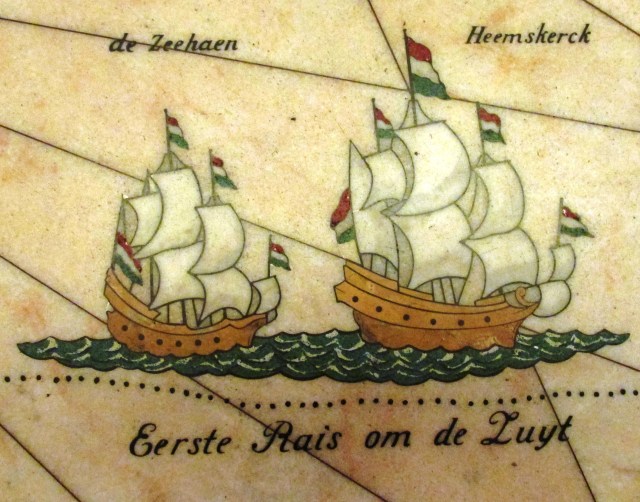
In the late afternoon of 24 November 1642, and thankfully still in daylight, the Dutch East India Company ships Heemskerk and the Zeehan sighted distant mountains. An overnight storm could dash them onto this unknown coast and they prudently decided to run out to sea until the next day:
We were on a latitude of 42 degree 25 minutes and a longitude of 163 degrees 31 minutes, the course was held northeast and we sailed thirty miles; the wind from the south-west, later from the south with a gentle topsail breeze; in the afternoon about 4 o’clock we saw land to the north-east of us some 10 miles away; it was very high-lying land; towards the evening we saw again three high mountains in the east-south-east and in the north-east also two mountains which were not as high as those in the south.
The land Abel Tasman sighted was the west coast of Tasmania near Macquarie Harbour. Before them were mountains clothed with dark forest which were subsequently named Mount Heemskerck and Mount Zeehaen in their honour by the British explorer Mathew Flinders.

Abel Tasman statue in Hobart (Cathy Morrison)
On 25 November Tasman’s journal records:
This land being the first land we have met with in the South Sea and as it has not yet been known to any European we called it Anthony van Diemens Land, in honour of the Governor-General, our illustrious master, who sent us out to make this discovery. The islands round about, as many as were known to us, we have named after the Honourable Councillors of India.

Tasman’s journal entry for November 24 and 25, 1642 (The Tasman Journal)
These islands on the south coast of Tasmania still have the names of De Wit, Sweers and Maatsuyker, the members of the Council of the Indies, who had signed their sailing orders. The fleet rounded the most southern part of Van Diemens Land and on 29 November the expedition approached what looked like a likely anchorage. The journal records:
In the evening about 5 o’clock we came before a bay which seemed likely to afford a good anchorage, upon which we resolved with our ship’s council to run into it, as may be seen from today’s resolution; we had nearly got into the bay when there arose so strong a gale that we were obliged to take in sail and to run out to sea again under reduced sail, seeing that it was impossible to come to anchor in such a storm; in the evening we resolved to stand out to sea during the night under reduced sail to avoid being thrown on a lee-shore by the violence of the wind.
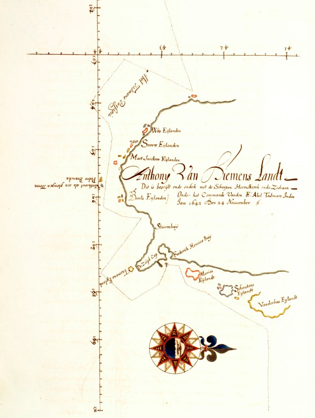
Map of Tasman’s voyage around Van Diemens Land, Francois Visscher (Algemeen Rijksarchief)
Storm Bay has retained the name given by Abel Tasman and by daybreak they found they were far offshore. After rounding South Cape (Cape Pillar) and Tasman Island they sailed northwest and on 1 December entered a wide sheltered bay they named Frederick Hendrik Bay after Prince Frederick of Nassau, the head of the Dutch Republic:
In the afternoon we hoisted the white flag upon which our friends of the Zeehaen came on board of us, with whom we resolved that it would be best and most expedient, wind and weather permitting, to touch at the land the sooner the better, both to get better acquainted with its condition and to attempt to procure refreshments for our own behalf … about one hour after sunset we dropped anchor in a good harbour, in 22 fathom, white and grey fine sand, a naturally drying bottom; for all which it behoves us to thank God Almighty with grateful hearts.
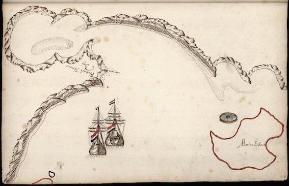
The ships at Frederick Hendrik Bay (Blackmans Bay)
The expedition had been at sea for 55 days since they left Mauritius and in the morning of December 2 two boats went ashore to search for water, firewood and what else may be available there. Francois Visscher was in charge of the pinnace from the Heemskerck, and was accompanied by the cock-boat from the Zeehaen. Both boats had musketeers on board, and the rowers were armed with pikes and side arms. They were gone the whole day and in the evening they delivered an account of their exploration to the ships Council:
The land was high, level and covered with vegetation (not cultivated, but growing naturally by the will of God). There was good timber but the water they found wasn’t deep enough to fill barrels, because the watercourse was so shallow that the water could be dipped with bowls only. This was impracticable in view of the amount of water they needed to bring aboard.
They did not see any native people during their visit but they heard sounds resembling a trumpet or a little gong, which they thought came from humans but which could equally have been bird sounds. They did however note physical evidence of the presence of people:
They saw two trees about 2 to 2 ½ fathoms thick and measuring 60 to 65 feet to the lowest branches and the bark of those trees was peeled off and they were notched with flint stones (to climb up and rob the nests of birds above) to form steps five feet apart, so that our men presumed that the people here must be very big or that they avail themselves of some practical means to climb the trees. In one of these trees these carved steps were very fresh and green as if they had been cut less than four days before.

A monument in Hobart showing the Heemskerk and the Zeehan (Cathy Morrison)
Abel Tasman left Van Diemans Land without having personally stepped ashore, without having met its people, or knowing if it was an island. It is interesting to speculate that if he had decided to explore the east coast of Australia, then the whole continent would have become known as Hollandia Nova and history would have been very different.


Great to revisit this key early European connection. Thanks Ian.
Thanks Ian. Great to revisit this wonderful period of European discovery and that it was some 150 yrs pre Cook.
Thanks Denis. I was really pleased to be able to post the 24 November, 1642 page from Tasman’s Journal.
Very interesting and well-written as always Ian.
Thanks Randall. How is the Sultans and Rajah’s book coming along?