
The Pacific Ocean was first sighted on September 25, 1513 by the explorer Vasco Balboa when he reached the summit of the Isthmus of Panama and viewed its huge expanse.
In 1520 Ferdinand Magellan and his Armada de Moluccas, on a planned voyage west towards the Spice Islands, discovered the Straits of Magellan and entered the Pacific Ocean.

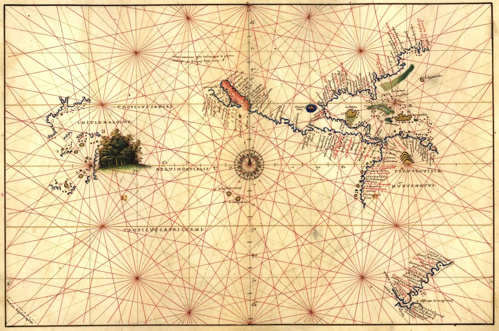
This map by Batista Agnese is really interesting because it shows how much and how little is known about the Pacific Ocean at the time of its first crossing by Magellan in 1521. During the Pacific crossing the expedition only found two unpopulated islands where they could replenish supplies. The great patch of green is of course the clove trees they were looking for in the Spice Islands.
This map by Abraham Ortelius shows the Victoria crossing the Pacific. The expedition was now down to three ships and had to face a long Pacific crossing with all the crew suffering from scurvy until they finally arrived in the Philippines. It is interesting that the map shows New Guinea as an island some fifteen years before Torres sailed through the Strait which bares his name in 1606.

In March 1606 the Dutch explorer Willem Janszoon in the yacht Duyfken reached the Cape York Peninsula which he considered as part of New Guinea, and it was in October of that same year that Luis Vas de Torres found his way through the Torres Strait.

This 1622 map of the Pacific Ocean by Hessel Gerritsz, the chief mapmaker for the Dutch East India Company, shows the first appearance of part of Australia on a world map, even if it is named as New Guinea.

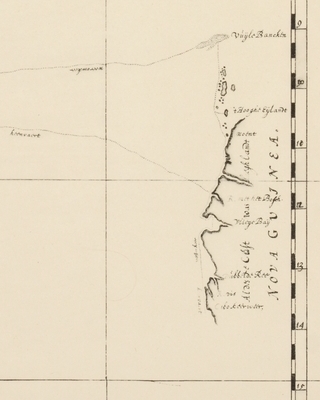
Detail from that map shows Cape York as discovered by Willem Janzoon and named Nueva Guinea. The text to the left reads – These parts were sailed into with the yacht of De Quiros about Nueva Guinea on 10 degrees westward through many islands and dry banks and over 2, 3, 4 fathoms for full 40 days. Presuming Nueva Guinea not to stretch over the 10 degrees south – if this were the case – then the land from 9 to 14 degrees must be separate and different from the other Nueva Guinea.
In other words – Australia!

Many of these maps are referred to in detail in the book The Tasman Map. Please go to the website below for more information.

Hi Ian,
Does anyone know what the two unpopulated islands that Magellan encountered in the Pacific are called today?
Randy
This is so well-researched, and such a joy to read. Thank you for sharing the products of your inquiry with us, Ian.
I’m curious as to how none of the islands we know refer to as Polynesian were encountered on these journeys, especially given that the inhabitants of those islands were wayfinding from island to island and would conceivably have crossed paths with the European ships.
*now
*Polynesia
=O
Pingback: The Vienna Globe Museum – The Navigators Blog