The 1934 air race from London to Melbourne was sponsored by Melbourne businessman and philanthropist Sir Macpherson Robertson, founder of the MacRobertson Confectionery Company. The race was initiated as part of the Melbourne and Victorian Centenary celebrations. An exquisite gold trophy, cash prizes of £15,000, and gold medals for all crew and passengers who reached Melbourne were provided by Robertson. He also wanted safety to be a priority.

Photo of a working model of the DC-2 aircraft and map (Ian Burnet)
KLM had made its first flight to the Dutch East Indies (now Indonesia) as early as the 1920s. By the mid-1930s the route — which had long-since become the most distant intercontinental route — had long since proven its success.
KLM entered a 14-seat Douglas DC-2 called the Uiver (Stork). This was run as a commercial flight, carrying three passengers (two Dutch bankers; Pieter Gilissen, Roelof Domenie and German aviatrix and journalist Thea Rasche) and 25,000 letters. KLM did the full 22 stop-over version of the race as shown on the dashed line.

Map showing the route of the Speed Race by Grosvenor House and the Handicap Race by the Uiver
Just 300km from Melbourne, the Uiver became lost at night in an electrical storm. The people of Albury came to the aid of the plane, in what is now a legendary story and the Uiver was able to make a landing on Albury Racecourse.
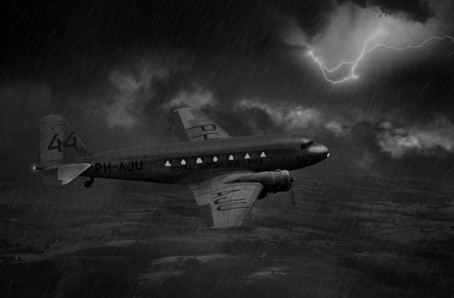
Artist’s impression of the Uiver in an electric storm
Race headquarters in Melbourne asked Albury newspaper sub-editor, Clifton Mott, to flash a light in Morse code. Mott met with Municipal Electrical Engineer, Lyle Ferris and they bumped into District Postal Inspector, Reg Turner, who knew Morse code. All three went to the Albury electrical sub-station where they signalled A-L-B-U-R-Y in Morse code by turning the town’s street lights on and off.
Arthur Newnham, the 2CO Radio announcer, called for cars to go to the Albury Racecourse to light a makeshift runway using their headlights to guide the plane to land, as there was no airport in Albury. About 80 cars arrived. Remarkably, Newnham’s broadcast went out at 12:54 am, and after circling the racecourse twice and dropping parachute flares, the Uiver was safely on the ground by 1:17 am!

A plaque commemorating the event was created in the Netherlands and donated to the people of Albury.
The DH 88 COMET named Grosvenor House was first to arrive at Melbourne, crossing the finishing line at Flemington racecourse at 3:34 pm on 23rd October 1934, a record time in the air of 70 hours, 54 minutes, 18 seconds.
After its forced landing at Albury the Uiver was freed from the mud on the morning of the 24th October, and minus two crew, passengers and cargo, was able to take off and fly to Melbourne to finish the race in second place overall, taking the handicap prize, despite the dramatic events of the night before. The Uiver’s flying time was 90 hours, 18 minutes, 51 seconds.

The return of the Uiver to Schipol Airport
A month later, the Uiver was greeted with great pomp at Schiphol Airport in Amsterdam . Enormous grandstands were set up on the grounds for the ceremony. On 21 November, the Uiver landed at Schiphol to the cheers of thousands of spectators. There was no shortage of memorabilia to commemorate the victory. Books, placards, pins, a song, epic poems, spoons, and plaques — nothing went too far.