
The new Amsterdam City Hall was completed in 1655. This remarkable building which was built on 13,659 wooden piles at a cost 8.5 million guilders, is now the Royal Palace and still dominates the Dam Square today. The relatively simple exterior of the city hall is stikingly different to the exuberant Baroque style of the interior, with its huge allegorical paintings and marble reliefs derived from the Bible and classical mythology.
Dam Stadhuis, Gerrit Berkhheyde, 1672, Rijksmuseum
At the centre of the building is the high-ceilinged Burgerzaal, which is a rare example for this period of a large non-religious architectural space. When the new city hall was completed, a large world map in two hemispheres composed of marble and copper was laid on the floor of the Groote Burgerzaal to celebrate the trade supremacy of the Dutch East India Company and the Dutch West India Company.

The Groote Burgerzaal in the Dam Stadhuis, 1661
Intended to impress visitors, the floor was a symbol in marble of the extension of Dutch seapower across the world. The Eastern hemisphere details the regions explored by the ships of the Dutch East India Company including the exploration of Hollandia Nova and the results of Tasman’s voyages.
Plan of the marble floor of the Groote Burgerzaal, 1661
Over a century this cartographical work of art was badly damaged by people walking over the floor and the two hemispheres were later filled in with plain marble slabs without any pictorial representation. This important cartographical monument was lost to posterity, however we have an image and a description from 1661:
One sees here in the centre, on the floor of the Groote Burgerzaal, two half spheres, bisected at the axis and a celestial hemisphere, of which each at the centre line or diameter is a length of approximately two-and-twenty and in its circumference approximately six-and-sixty feet. On the one terrestrial hemisphere, towards the east in the Burgerzaal, the contours of the outermost limits of the three parts of the world, to wit Europe, Asia and Africa, as also even the islands, promontories, rivers and oceans, and parts of Hollandia Nova are shown very ingeniously by red and other coloured inlaid stone.

Detail of the Eastern Henisphere showing Hollandia Nova and Van Diemens Land
In 1746 the Amsterdam Government commissioned Jacob Martenesz to execute a new world map of two hemispheres in marble to replace those of 1655. For reasons unknown the work was not used as intended and remained forgotten in a store-room of the City Hall. It was not until 1953 that the forgotten marble maps were finally installed in their intended place in the Groote Burgerzaal. The eastern hemisphere shows Nova Hollandia, including Terra Concordia (Eendrachslandt) and Terra Diemensis (Van Diemens Landt) all based on the 1644 Tasman Map.
The Groote Burgerzaal and its marble maps
Detail of the 1746 marble map of Nova Hollandia in the Groote Burgerzaal. Photo Ian Burnet
Commissioned by the Principal Librarian William Ifould, the marble mosaic map in the vestibule of Mitchell Library was intended to celebrate Abel Tasman, the early Dutch discoveries of Australia and the Tasman Map of 1644, just as these voyages were celebrated in marble on the floor of the Groote Burgerzaal in Amsterdam.
Work commenced in 1939 by the Melocco Brothers of Annandale who as master craftsmen took eighteen months and an incalculable degree of skill, knowledge and patience to create one of the most immpressive mosaic floors in the world. A ‘must see’ on your next visit to the State Library of NSW
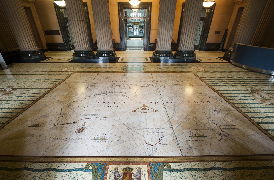
The marble mosaic Tasman Map in the vestibule of the Mitchell Library. State Library NSW

Fascinating. Once again, thanks Ian.
Hi Ian
Wonderful expose of the connection between the Groote Burgerzaal original Maps illustrating the amazing voyages of the VOC and the early charting of Australia, with the Tasman Map in the Mitchell Library. both in the period 1644.-1655. You must tell me about your trip to Amsterdam when next we meet.
Thanks Richard. Let’s try and meet sometime at the Mitchell Library to admire the marble map mosaic.
Many thanks Ian for all your research & such an important historical story, keep up your excellent work!
Next time in Amsterdam I will make sure to have a look Ian, thanks!!
Thanks Ria and it is well worth a visit
Pingback: eCARTO News July 2020 International Cartographic Association
Thank yoou for sharing this